ETHAN DANIELS/SHUTTERSTOCK.COM

STANDARDS

NGSS: Core Idea: LS2.C   

CCSS: Writing: 1   

TEKS: 7.10A, 8.11A, B.12E

Mapping Mangroves

A teen draws attention to the threats facing one of nature’s most important forest ecosystems

ESSENTIAL QUESTION: How do scientists monitor the health of ecosystems?

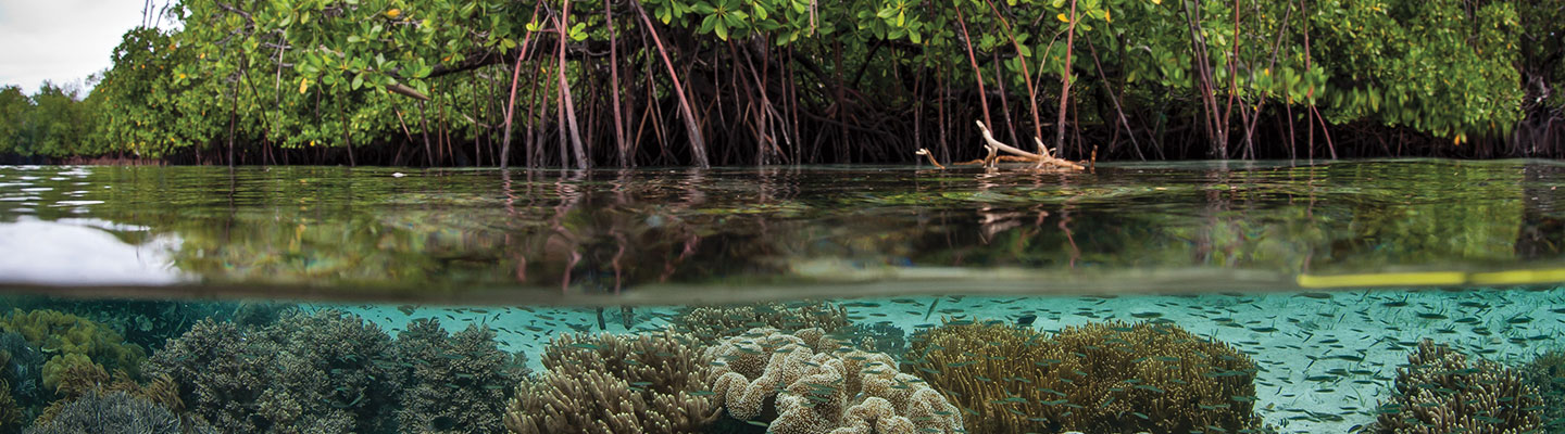
Not many teenagers can say they work at NASA. But then again, not many teens are quite like 16-year-old Liza Goldberg. For the past two years, she has helped researchers at NASA’s Goddard Space Flight Center in Maryland develop new ways of protecting one of Earth’s most important ecosystems: mangrove forests.

Not many teenagers can say they work at NASA. But not many teens are quite like 16-year-old Liza Goldberg. For the past two years, she has helped researchers at NASA’s Goddard Space Flight Center in Maryland. She’s working on new ways to protect mangrove forests. They are one of Earth’s most important ecosystems

TONI L. SANDYS/THE WASHINGTON POST VIA GETTY IMAGES

TEEN SCIENTIST: Liza keeps a busy schedule. In addition to presenting at conferences and working at the lab, she’s a competitive swimmer.

The shrubs and trees that make up mangrove forests grow only in the area between high and low tides along tropical coasts. These intertidal zones are hot, waterlogged, and salty. Mangroves have developed specialized adaptations that help them survive these conditions, which would kill most plants. Their most distinctive feature is their tall, stilt-like roots. They help anchor the plants in the mud and provide a habitat for birds, fish, and other aquatic creatures.

Unfortunately, mangroves are under threat almost everywhere they grow around the world, including the U.S. (see Mangrove Range). Human development, agriculture, and climate change—long-term changes to global weather patterns—have taken a heavy toll on these ecosystems. Liza, now a junior in high school, is working with NASA to use satellite images to track the health of these priceless forests.

The shrubs and trees in mangrove forests grow only in the area between high and low tides along tropical coasts. These intertidal zones are hot, watery, and salty. Mangroves live in conditions that would kill most plants. They have specialized adaptations that help them survive. Their most unusual feature is their tall, stilt-like roots. These help hold the plants in the mud. They also provide a habitat for birds, fish, and other animals that live near water.

Sadly, mangroves are in danger almost everywhere they grow around the world. That includes the U.S. (see Mangrove Range). Human development and farming have taken a heavy toll on these ecosystems. So has climate change—long-term changes to global weather patterns. Liza is now a junior in high school. She’s working with NASA to use satellite images to track the health of these priceless forests.

TEEN SCIENTIST

Growing up in Maryland, Liza wasn’t thinking much about tropical mangroves. But she was worried about how a warming climate might affect plant life.

For a middle school science project, Liza researched how temperature changes affect the ability of maple trees to absorb carbon dioxide (CO2) from the air. Plants use sunlight and water to convert this gas into food—a process known as photosynthesis.

Liza grew up in Maryland, so she wasn’t thinking much about tropical mangroves. But she worried about a warming climate. How might this affect plant life?

For a middle school science project, Liza looked at maple trees. She researched how temperature changes affect the way they absorb carbon dioxide (CO2) from the air. Plants use sunlight and water to change this gas into food. The process is called photosynthesis.

ETHAN DANIELS/SHUTTERSTOCK.COM; MIREK KIJEWSKI/SHUTTERSTOCK.COM (BLUE TANG)

Liza’s work caught the attention of a science-fair judge, who recommended her for an internship at NASA. Two Goddard scientists—Lola Fatoyinbo, an environmental scientist, and David Lagomasino, a geologist—were impressed by the then eighth-grader’s application. So they invited her to come work in their lab, which studies mangroves using remote sensing. This technique gathers information about Earth’s physical characteristics using technology like imaging satellites.

Liza studied the topic by reading every scientific paper on remote sensing and mangroves she could find. What she discovered surprised her. “Mangroves have a higher rate of deforestation than rainforests,” says Liza. “Over the past 50 years, we’ve lost half of all mangroves. And in many regions, those rates of loss are not going down.”

A science-fair judge noticed Liza’s work and recommended her for an internship at NASA. Liza was an eighth-grader then. Her application impressed two Goddard scientists. They were Lola Fatoyinbo, an environmental scientist, and David Lagomasino, a geologist. So they asked her to come work in their lab. They study mangroves using remote sensing. This process uses technology like satellite images to gather information about Earth’s physical features.

Liza studied the subject. She read every scientific paper she could find on remote sensing and mangroves. What she learned surprised her. “Mangroves have a higher rate of deforestation than rainforests,” says Liza. “Over the past 50 years, we’ve lost half of all mangroves. And in many regions, those rates of loss are not going down.”

VITAL ECOSYSTEM

NASA uses its satellites to study mangroves because of the trees’ ability to capture carbon dioxide from the air. CO2 is a greenhouse gas that absorbs heat in Earth’s atmosphere, warming the planet. “Mangroves store a lot of carbon in the trees and in the soil underneath their roots—two to three times more per acre than other ecosystems,” says Fatoyinbo.

But these ecosystems do more than help remove CO2 from the air. Many species thrive in and around mangrove forests. Their root systems protect fish laying their eggs and raising their young. The branches shelter many bird species. And all sorts of creatures—from insects to tigers—spawn, nest, find shelter, or hunt around mangroves. Together, these animals create a vast and intricate food web—an interconnected system where organisms eat other organisms to obtain energy (see Mangrove Food Web).

People also need mangroves. Large mangrove forests collect sediment, like sand and silt, which builds up shorelines. That helps prevent coastal erosion—the wearing away of coastlines by flooding and waves. In addition, deep-rooted mangroves serve as a buffer against big storms and enormous waves called tsunamis, protecting coastal communities further inland.

Why does NASA use satellites to study mangroves? Because the trees are good at taking carbon dioxide from the air. CO2 is a greenhouse gas that absorbs heat in Earth’s atmosphere. This warms the planet. “Mangroves store a lot of carbon in the trees and in the soil underneath their roots—two to three times more per acre than other ecosystems,” says Fatoyinbo.

These ecosystems help remove carbon from the air. But that’s not all they do. Many species live in and around mangrove forests. Their root systems protect fish laying their eggs and raising their young. Many bird species live in the branches. Mangroves help all sorts of creatures, from insects to tigers. The animals spawn, nest, find shelter, or hunt around mangroves. Together, these animals form a large and complex food web. That’s an interconnected system where organisms eat other organisms to get energy (see Mangrove Food Web).

People also need mangroves. Large mangrove forests collect sediment, like sand and silt. Sediment builds up shorelines. That helps prevent coastal erosion—the wearing away of coastlines by flooding and waves. And deep-rooted mangroves help shield against big storms and huge waves called tsunamis. This protects coastal communities farther from shore.

ECOMAP

While interning at NASA, Liza began using satellite data and software called Google Earth Engine to make a new research tool. “I wanted to create a program that predicts mangrove loss and identifies its causes,” says Liza. “And I wanted it to function on a global scale.”

Working after school, on weekends, and over holidays, Liza has come close to her goal. She recently presented a prototype, or working model, of her Electronic Coastal Monitoring and Assessment Program, or EcoMap, at a conference hosted by Google in Ireland.

As an intern at NASA, Liza began making a new research tool. She used satellite data and software called Google Earth Engine. “I wanted to create a program that predicts mangrove loss and identifies its causes,” says Liza. “And I wanted it to function on a global scale.”

Liza worked after school, on weekends, and during holidays. Now she’s close to her goal. She made a prototype, or working model, of her Electronic Coastal Monitoring and Assessment Program, or EcoMap. She recently showed it at a conference hosted by Google in Ireland.

EcoMap assesses the health of mangrove forests based on factors like land use and sea level change. The risk level is color-coded and put on satellite images so people can see how and why particular mangrove forests are threatened (see EcoMap in Action).

Liza hopes to provide this information freely to anyone who wants to use it to protect mangroves. “My dream is to use EcoMap and other satellite-based tools to help inform international policy and mangrove restoration,” says Liza. “I want this program to give coastal communities the ability to track how their environments are changing, in order to benefit both their local region and the wider world.”

EcoMap rates the health of mangrove forests. It looks at factors like land use and sea level change. The risk level is color-coded and put on satellite images. It shows people how and why each mangrove forest is in danger (see EcoMap in Action).

Liza hopes to provide this information freely. Then anyone who wants to protect mangroves can use it. “My dream is to use EcoMap and other satellite-based tools to help inform international policy and mangrove restoration,” says Liza. “I want this program to give coastal communities the ability to track how their environments are changing, in order to benefit both their local region and the wider world.”  

CORE QUESTION: Would remote sensing be a useful way to monitor other ecosystems on Earth? Provide evidence to support your answer.

videos (1)
Skills Sheets (4)
Skills Sheets (4)
Skills Sheets (4)
Skills Sheets (4)
Lesson Plan (2)
Lesson Plan (2)
Text-to-Speech