Photo of people on a ship in the waters of Antarctica

HAILEE ROMAIN

STANDARDS

NGSS: Core Idea: ESS2.C, ESS3.D, ESS2.A

CCSS: Literacy in Science: 7

TEKS: 6.2B, 6.5G, 7.2B, 7.5G, 8.2B, 8.5G, E.9D, E.9E

Expedition to Antarctica

A Science World writer joins researchers on a once-in-a-lifetime trip to photograph melting glaciers

As you read, think about why scientists are concerned about the loss of glaciers around the world.

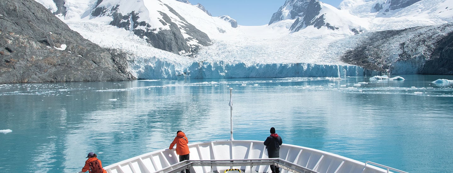
It’s not every day that a chunk of ice the size of a city block floats past your window—unless you’re on a ship traveling through the waters surrounding Antarctica. There, icebergs are a common sight. For three weeks in November 2021, I got the chance to explore the Antarctic while joining scientists and photographers on an expedition to the region.

This voyage brought together researchers studying different aspects of Antarctica—including scientists who had come to document glaciers and how they are changing. The icebergs we’d spotted had broken off from these slow-moving masses of ice and snow.  We sailed near a few glaciers during the trip. Up close, it was like looking at a wall of ice the height of a skyscraper!

A chunk of ice as big as a city block floats past the window. That’s not something you see every day, unless you’re on a ship in the waters around Antarctica. Icebergs are common there. I got the chance to explore the Antarctic in November 2021. For three weeks, I joined scientists and photographers on an expedition to the region.

The researchers on this voyage were studying different aspects of Antarctica. Some of them had come to document glaciers and how they are changing. Glaciers are slow-moving masses of ice and snow. The icebergs we saw had broken off from glaciers. We sailed near a few glaciers during the trip. Up close, it was like looking at a wall of ice as tall as a skyscraper!

LINDSEY GROTHKOPP

POLAR EXPLORER: Writer Hailee Romain visits the Antarctic.

Currently, glaciers cover about 10 percent of land on Earth. But many are melting at a rate that has scientists alarmed. Glaciers are disappearing because average global temperatures are rising as a result of climate change. Over the past 15 years, researchers with the Extreme Ice Survey (EIS) have recorded the loss of glacier ice from sites in the U.S., Europe, Greenland, Iceland, and Antarctica. 

Photographer James Balog started the EIS in 2007. He designed a system that uses dozens of cameras installed at sites around the world. He secured the cameras near glaciers and set them to snap pictures every half hour. Some of these cameras operated for more than 16 years. The resulting 1.7 million images have been compiled to create long-term time-lapse footage of glaciers. 

During the expedition to Antarctica, I spent time with naturalist and photographer Eric Guth. He showed me some of the EIS time-lapse videos. I was shocked to see how some of the glaciers we visited had changed in just the past year. “The footage allows people to watch a year’s worth of glacial movement in minutes,” Guth told me. “That can be mesmerizing—or alarming.” The videos also help scientists better understand how climate change is affecting glaciers around the globe.

Today glaciers cover about 10 percent of land on Earth. But many are melting quickly, and scientists are alarmed. Glaciers are disappearing because average global temperatures are rising. That’s a result of climate change. Over the past 15 years, researchers with the Extreme Ice Survey (EIS) have recorded the loss of glacier ice. They’ve studied sites in the U.S., Europe, Greenland, Iceland, and Antarctica. 

Photographer James Balog started the EIS in 2007. He designed a system with dozens of cameras at sites around the world. He secured the cameras near glaciers and set them to snap pictures every half hour. Some of these cameras operated for more than 16 years. The result was 1.7 million images. They’ve been put together to create long-term time-lapse footage of glaciers. 

During the expedition to Antarctica, I spent time with Eric Guth. He’s a naturalist and a photographer. Guth showed me EIS time-lapse videos of some of the glaciers we visited. I was shocked at how they had changed in just the past year. “The footage allows people to watch a year’s worth of glacial movement in minutes,” Guth told me. “That can be mesmerizing—or alarming.” The videos also help scientists better understand the effects of climate change on glaciers around the globe.

©2014 EARTH VISION TRUST/JAMES BALOG (EIS CAMERA)

CAMERA INSTALLATION: Scientists bolt an EIS camera into rock.

DOCUMENTING CHANGE: The Extreme Ice Survey monitors glacier changes over time.

RIVERS OF ICE

Glaciers are found in cold regions near Earth’s poles, as well as in mountain ranges around the  world. Glaciers form when layers of snow are compacted into ice over centuries (see Anatomy of a Glacier). As each year’s snowfall compresses the layers below, air bubbles are squeezed out. Eventually this process creates a dense, pure ice with a brilliant blue color. Under the pressure of the ice’s own weight and the pull of gravity, glaciers flow slowly downhill like frozen rivers.

Sometimes, a piece of ice breaks off from a glacier, creating an iceberg. This phenomenon is known as calving. One day, our ship was anchored near a glacier when we heard a loud CRACK, followed by a muffled roar. Chunks of ice the size of a small car began to splash into the water from the glacier. Luckily, the ship was a safe distance away!

Glaciers retreat and advance in response to changes in temperature and snowfall. “There’s a natural gain and loss throughout the year,” explains Dan McGrath, a glaciologist at Colorado State University and part of the EIS team. Historically, the amount of water that melted from a glacier in warmer months was roughly the same as the amount of snow that fell on it in the winter.

But as temperatures on Earth rise, there is less winter snowfall and more melting taking place in summer. “For most glaciers around the world, we’re seeing that the losses are now larger than the gains,” says McGrath. 

Between 2000 and 2019, the world’s glaciers lost an average of 267 billion tons of ice per year (see Disappearing Ice). As glaciers melt, the excess water they release pours into Earth’s oceans. This is causing sea levels to rise. If glaciers melt at predicted rates, scientists estimate sea levels could rise by a meter (3.3 feet) by 2100. As a result, many low-lying coastal areas could experience severe flooding.

Glaciers are found in cold regions near Earth’s poles. They’re also in mountain ranges around the world. Over centuries, layers of snow are compressed into ice to form glaciers (see Anatomy of a Glacier). Each year’s snowfall compresses the layers below, and air bubbles get squeezed out. Over time, this creates a dense, pure ice with a brilliant blue color. The ice’s own weight and the pull of gravity cause glaciers to flow slowly downhill. They move like frozen rivers.

Sometimes, a piece of ice breaks off from a glacier. It becomes an iceberg. This process is known as calving. One day, our ship was anchored near a glacier. We heard a loud CRACK and then a muffled roar. Chunks of ice began to splash into the water from the glacier. They were the size of small cars. Luckily, the ship was a safe distance away!

Glaciers retreat and advance because of changes in temperature and snowfall. “There’s a natural gain and loss throughout the year,” explains Dan McGrath. He’s a glaciologist at Colorado State University and part of the EIS team. Water melts from a glacier in warmer months, and snow falls on it in winter. In the past, the amounts of lost water and added snow were about the same.

But temperatures on Earth are rising. Less snow falls in winter, and more melting happens in summer. “For most glaciers around the world, we’re seeing that the losses are now larger than the gains,” says McGrath. 

From 2000 to 2019, the world’s glaciers lost an average of 267 billion tons of ice per year (see Disappearing Ice). As glaciers melt, the water they release pours into Earth’s oceans. This is causing sea levels to rise. Scientists have predicted how fast glaciers will melt. They estimate that sea levels could rise by a meter (3.3 feet) by 2100. As a result, severe flooding could hit many low-lying coastal areas.

A CLOSER LOOK

While on my Antarctic trip, I joined expedition member Guth as he collected footage from EIS cameras and checked on the equipment. Although it was early summer in Antarctica, temperatures hovered around a frigid -6°C (20°F). Strong winds made it hard to walk.

To protect the cameras from this harsh environment, each is housed in a sealed case with a small plastic window for the lens. An attached solar panel charges the camera’s battery. The case is secured to a 2.4 m (8 ft) post to prevent it from getting buried in snow. The post is bolted into underlying rock and secured with steel wires to keep it stable in strong winds.

Despite all these precautions, electronics can still fail or winds can rip off solar panels. “It’s challenging to keep the cameras going in these conditions,” says Guth. “But the on-the-ground perspective they offer is very powerful.”

Since the 1950s, scientists have been studying glaciers using data collected by satellites. From high above Earth, satellites’ cameras and instruments can track glaciers’ size, shape, and movement. This data is combined with photos gathered by EIS, which provide information at ground level. Together, the different types of detailed imagery can help experts create computer models and graphs to predict how glaciers might change in the future.

During my Antarctic trip, expedition member Guth collected footage from EIS cameras and checked on the equipment. I joined him. It was early summer in Antarctica, but temperatures stayed around a frigid -6°C (20°F). Strong winds made it hard to walk.

Cameras need protection from this harsh environment. So each camera is inside a sealed case with a small plastic window for the lens. The case has a solar panel attached. It charges the camera’s battery. The case is secured to a 2.4 m (8 ft) post. That prevents it from getting buried in snow. The post is bolted into underlying rock and secured with steel wires. That keeps it stable in strong winds.

Even with these precautions, electronics can still fail. And winds can rip off solar panels. “It’s challenging to keep the cameras going in these conditions,” says Guth. “But the on-the-ground perspective they offer is very powerful.”

Since the 1950s, scientists have used satellite data to study glaciers. Satellites have cameras and instruments to track glaciers’ size, shape, and movement from high above Earth. This data is combined with photos from EIS. The photos provide information at ground level. Together, the different types of imagery can help experts create computer models and graphs. This allows them to predict how glaciers might change in the future.

JAMES BALOG/EXTREME ICE SURVEY (2007, 2015)

SHRINKING GLACIER
2007: A view of the Mendenhall Glacier in Alaska captured by an EIS camera
2015: The same glacier, now much smaller, as seen by EIS eight years later

A POWERFUL TOOL

While watching massive glaciers crumble into the sea, I realized that I was witnessing the effects of climate change firsthand. It’s something few people get to see in person. That’s what makes projects like the EIS so impactful, says McGrath. It brings the reality of climate change to life in a way that pure scientific data can’t.

“Climate change can seem abstract,” says Balog, EIS’s founder. “Our goal is to turn those environmental consequences into imagery that people can understand.” He and his colleagues hope that their project will raise awareness about the threats to glaciers—and inspire people to take action to fight climate change. 

As I watched massive glaciers crumble into the sea, I was seeing the effects of climate change firsthand. Few people get to see that in person. That’s what makes projects like the EIS so impactful, says McGrath. It brings the reality of climate change to life. Pure scientific data doesn’t have the same effect.

“Climate change can seem abstract,” says Balog, EIS’s founder. “Our goal is to turn those environmental consequences into imagery that people can understand.” He and his colleagues want to raise awareness about the threats to glaciers. They hope that their project will inspire people to act to fight climate change.

SANDRA NELSON/ALAMY STOCK PHOTO

MEETING THE LOCALS: Romain and her shipmates encountered Adélie penguins (pictured) and three other penguin species.

COMMUNICATING INFORMATION: Describe two ways EIS designed its camera setup to withstand the harsh environment.

What does your class think?

Would you travel on an expedition to Antarctica?

Please enter a valid number of votes for one class to proceed.

Would you travel on an expedition to Antarctica?

Please select an answer to vote.

Would you travel on an expedition to Antarctica?

0%
0votes
{{result.answer}}
Total Votes: 0
Thank you for voting!
Sorry, an error occurred and your vote could not be processed. Please try again later.
videos (1)
Skills Sheets (4)
Skills Sheets (4)
Skills Sheets (4)
Skills Sheets (4)
Lesson Plan (2)
Lesson Plan (2)
Text-to-Speech